 (1)
(1)Hata Model
In
this model, an empirical formula for propagation loss is derived from
Okumura’s tests in order to put his prediction method to computational use
[1]. This model tries to put Okumura’s observations into a simple form as A+
BlogR, where A and B are frequency and antenna height functions and R is the
distance. All formulas derived by Hata are given in terms of Path Loss. Hata’s
approach involves dividing the prediction area into a series of clutter and
terrain categories, namely open, suburban and urban area. These could be defined
as [2]:
Urban
Area: Large
town with large buildings and houses with two or more floors, or larger villages
with close houses.
Suburban
Area:
Village or highway scattered with trees and houses, some obstacles near the
mobile but not very congested.
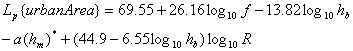
Hata’s formulas:
(1)
* Correction factor
for mobile station antenna height
medium –small city
![]() (2)
(2)
large city
for f<=200 MHz
![]() (3)
(3)
for f>400MHz
![]() (4)
(4)
![]() (5)
(5)
![]() (6)
(6)
The introduced formula doesn’t cover all conditions proposed in the Okumura’s report. Hata’s approach is valid for restrictions given in Table 1
|
Frequency (f) |
100-1500 MHz |
|
Distance (km) |
1-20 km |
|
Base Station Effective Antenna Height (hb) |
30-200 m |
|
Mobile Antenna Height (hm) |
1-10 m |
Table 1. Limitations in Hata’s formula
By
using Wireless Simulator Programâ following study is done to give an idea how Hata approach
works.
Okumura-Hata Path Loss study is done with Open Area and Okumura- Hata Path Loss (1) is done with Urban Area as area type.
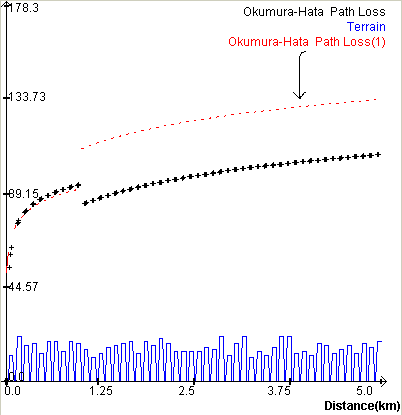
Figure 1 Hata Study Example
Study Parameters: Frequency: 900 MHz, TX Height (hb)=50m Mobile Height (hm)=1.5m TX Gain: 13 dBi City Size: Small/Medium
Terrain Parameters: Average Width: 50.19 m Average Building Height: 16.1m Percentage of Buildings: 62%
Since
Hata model is valid for distances greater than 1 km, Wireless Simulator program
applies free space propagation up to distance 1km. Therefore, up to that
distance, both study have the same results.
As
seen in the figure 1, path loss in urban area has about 28.5 dB
differences from path loss in Open Area. Actually, this difference is caused by
the formula (6). The parameters
![]()
yield the same value.
For the frequency between 200 MHz and 400 MHz (formula 3 and 4), the model doesn’t recommend anything. However, some sources propose solution to the problem by applying the formulas for f>300 MHz, and f<300 MHz respectively [3]. For the mobile height hm=1.5m, formulas (3) and (4) yield
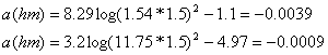
These
values imply that solution mentioned above will deviate in small differences
from Hata’s actual results and could be accepted in practical applications.
This model works sufficiently for large cell mobile systems, but not for cells with radius in order of 1 km.
[2] Siwiak, Kazimierz., “Radiowave Propagation and Antennas for Personal Communications”, Artech House, Boston-London,1995
[3] Allsebrook, K. and J.D. Parsons., “Mobile Radio Propagation in British Cities at Frequencies in the VHF and UHF Bands,” IEEE Proc. Vol.124,No.2,1997, pp.95-102